To display in FULL SCREEN hover the cursor over the image above and click the top left zoom button
The Pre-Suburb Landscape and its Legacy
The Suburb we have today took a lot of inspiration from the pre-existing landscape. The natural landscape on which the Suburb was built greatly influenced Raymond Unwin in planning the original layout of the Suburb. Much of this pre-existing world survives, either intact or as a ghost in the present topography of the Suburb.
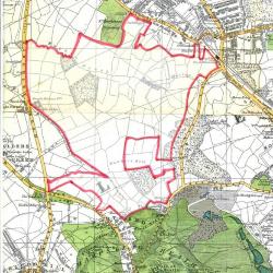
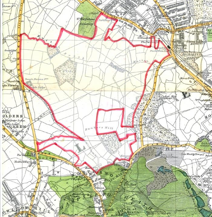
The land on which the Suburb now sits was once part of a large swathe of uncultivated heathland across north London. Eton College acquired it from Henry VI in 1449, and the heath was progressively cleared and enclosed as more productive fields. By the time Mrs Barnett and Raymond Unwin stomped across it in 1906, the 243 acres of farmland that were to form the original Suburb were a patchwork of mostly pasture, divided by thickset hedges with numerous hedgerow oaks.
Unwin carefully surveyed the site and recorded the position of every hedgerow and tree. Onto this framework, he then plotted the roads and housing groups, the roads curving to follow contours where they could, and the houses stepping forward or back as needed to accommodate the trees – to preserve, as he said, “as much as possible of the natural beauty of contour and of scenery”. The original Suburb could thus be thought of as a sort of shadow-projection of the landscape under it.
So where can we still find evidence of this lost landscape?
The future site of Central Square was a low rounded hill. Edwin Lutyens levelled this off to create the present flat Square, but its original contours can still be seen by the Free Church, which sits lower than the main Square, and the North Square houses, which sit lower still.
An ancient manorial boundary can still be seen in the north-east corner of the Square at the junction with Northway, where a corner of Big Wood curtails Lutyens’ otherwise formal housing group.
The shape and alignment of the whole Square was dictated by field boundaries, including a still-visible field boundary behind the tennis courts.
The footpath across Crossways Garden to Hampstead Way and down to Temple Fortune Lane follows an old field boundary, including several former hedgerow oaks.
The rather irregular property frontages to Temple Fortune Lane reflect its former role as the back lane from Hendon serving various farms along its route, including Temple Fortune Farm (now Farm Walk Tennis Club), Wildwood Farm and Wyldes Farm. This lane continues across Meadway Gate to become Wild Hatch, then as a track across the Heath Extension to North End.
The Heath Extension itself preserves all the original field boundaries, and its southern end preserves the best impression of the pre-Suburb landscape.
Other parts of the Suburb also preserve the old landscape in their shape and the trees that Unwin retained. For example, Meadway is centred on the field called Four Acre Mead; part of Willifield Way and Erskine Hill follow old field boundaries, allowing hedgerow trees to border the new roads. Asmuns Place lies entirely within Lower Asmuns field; Queens Court sits within Near Cock field; and Childs Hill Way follows an old hedgerow marked by ancient oaks.
I hope this has given you a new appreciation of just how much the layout of the Suburb owes to the underlying landscape, and how its bones are still there to see – if you just know where to look!
Click here to view a map of the original fields overlaying the modern Hampstead Garden Suburb.
Simon Henderson
HGS Trust Chief Executive