To display in FULL SCREEN hover the cursor over the image above and click the top left zoom button
Introduction for the Field Boundary Map
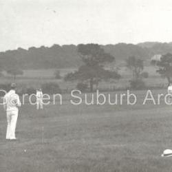
Suburb Archives has a photograph 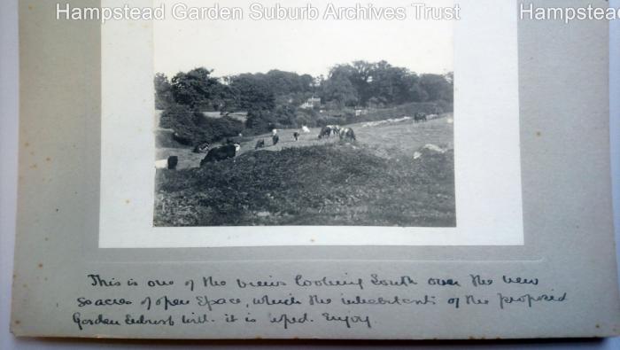 taken by Henrietta Barnett showing cows munching contentedly in a field surrounded by hedgerows, with woods beyond, below which Henrietta has written: “This is one of the views looking south over the new 80 acres of open space, which the inhabitants of the proposed Garden Suburb will, it is hoped, enjoy”. The 80 acres were the land being acquired from Eton College and which became the Heath Extension. They were formed from Wyldes Farm, the buildings of which can still be seen near the junction of Wildwood Road and Hampstead Way.
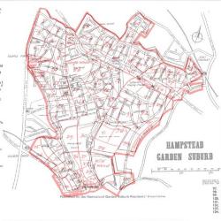
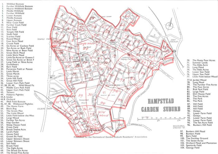
Suburb Archives has a number of maps showing the names and boundaries of the fields that covered the estate before the Suburb was built.
The task of identifying which field any particular location is in, was made much easier when a map of the field boundaries, annotated with their names, was issued by the Residents Association in 1968, superimposed on the map Michael Darke produced for the RA in 1957, the year of the Suburb’s Golden Jubilee. An updated version of the 1957 map is still used in the Residents Association’s Suburb Directory.
It is not clear who produced the field boundary overlay map, but a likely candidate is Christopher Ikin, who was a member of the RA Council at the time. A solicitor by profession, he lived at the top of Wildwood Road. He was a leading light in the protection group that led to the formation of the present Hampstead Garden Suburb Trust in 1968 and an avid local historian, publishing books on how Hampstead Heath was saved and on the History of the Suburb. Suburb Archives has a thick folder of maps annotated by him showing land ownership and development in the area from the 1500s.
The source material for the fields Henrietta Barnett acquired from Eton College was a survey the College undertook in 1800. The rest of the Suburb was acquired from the Church Commissioners (as they are now called) in 1911 and the source for that area was the 1841 Tithe Award Map. Tithes were originally an annual tax which required a tenth of all agricultural produce to be paid to support the local church and clergy. In 1836 an Act converted those that were still payable in kind into monetary amounts and a survey was undertaken and a map drawn up to establish who was entitled to what.
The Suburb field boundary map has some familiar names: “Willifield Bottom”, “Further Willified Bottom” and “Nearer Willifield Bottom” are all close to where Willifeld Way begins at the Finchley Road end. Finchley Road itself was constructed following an Act of 1825 authorising the establishment of tolls and turnpikes. “Lower Asmuns”, “Middle Asmuns” and “Upper Asmuns” also have a familiar ring, giving their name to Asmuns Place and Asmuns Hill. Perhaps in the distant past they were the “Assman’s” fields.
Apart from Willifield and Asmuns, not many names have found their way into our road names – roads are mostly named after notable figures involved with the foundation of the Suburb, artists, writers and lawyers. Nor do the roads tend to follow field boundaries, with the curious exception of Spencer Drive. Hampstead Way and Wildwood Road do run close to field boundaries - there are four “Wild Wood Fields” and three “Wildwood Pightles”. A “pightle” is a small enclosure. (“Plightles” is a misprint.)
The field boundary map is a fascinating reminder of the rural origins of the Suburb. No previous habitation is known to have existed on the site, which therefore comprised woodland and agricultural land from earliest times. These pre-existing hedgerows, oak trees and farm tracks influenced Raymond Unwin’s Suburb plan. He was a man before his time in respecting the underlying ecology of the site. We benefit from his vision and owe it to future generations to preserve as much as possible of what survives of our rural past.